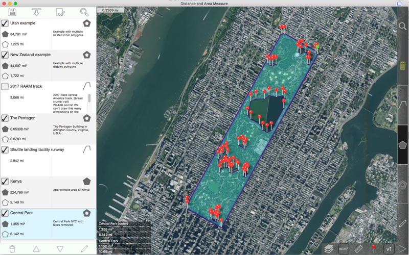
Distance and Area Measure
Über Distance and Area Measure
Messen, Land, Länder, Straßen, Parks, Seen, etc. aus einer Satelliten-Ansicht. Entfernungen, Flächen und Umfänge berechnet.
Funktionen, die diese Anwendung bietet, dass die meisten Konkurrenten nicht tun:
- Abstand und Fläche Einheiten.
- Innere Polygone zu zeichnen. Z. B. Landfläche mit Gewässer entfernt.
- Fügen Sie einen Punkt in die Mitte eines Pfades (die meisten nur ermöglichen es Ihnen, am Ende des Pfads hinzufügen) links klicken, um das Ende eines Pfades hinzufügen. Rechts klicken Sie und in der Mitte eines Pfads hinzufügen.
- Tauschen Sie zwei Punkte in einem Pfad oder Polygon.
- Können komplexe Polygone (sich selbst schneidenden) behandeln.
- Verträgt verschachtelte inneren Polygone.
Merkmale:
- Exportieren und Importieren von KML-Dateien
- Pins sind verschiebbar
- Name, Notizen und Farbe Felder für jeden Pfad und Polygon
- 4 Ausführlichkeit Modi.
- Undo / Redo
- Geokodierung: Suche nach Postleitzahl, Stadt, Adresse usw., Breite und Länge für eine Adresse zu finden
- Reverse Geocoding: Finden Sie in der Nähe Adressen für eine breite und Länge
3 Zeichen-Modi:
- Pfad
- Polygon
- Innere Polygon
Werte für Pfade angezeigt:
- Gesamtstrecke
- Inkrementelle Abstand für jeden Wegpunkt
Werte für Polygone angezeigt:
- Bereich
- Perimeter
- Entfernung für jede Seite
Fügen Sie Punkte auf einem Pfad oder Polygon in 1 von 3 Möglichkeiten:
- Klicken Sie auf die Karte
- Koordinaten manuell eingeben
- KML-Datei import
Standard-Distanz-Einheiten sind:
- Kilometer
- Miles
- Nautische Meilen
- Meter
- Füße
- Yards
Standardeinheiten Bereich umfassen:
- M ²
- Füße ²
- Yards ²
- Km ²
- Meilen ²
- Nautische Meilen ²
- Ha
- Ha
Koordinaten-Formate:
- Grad
- Grad, Minuten
- Grad, Minuten, Sekunden
Beachten Sie, dass diese Anwendung Apple Maps verwendet. Die Satellitenbilder können wir nicht ändern. Wenn Sie feststellen, dass die Bilder unscharf oder veraltet sind, melden Sie dies bitte an Apple nach der Überprüfung, die das Problem auch in der Karten-app von Apple existiert.
Bitte besuchen Sie die Support-Seite für weitere Informationen.
English:
Measure roads, parks, land, countries, lakes, etc from a satellite view. Calculates distances, areas, and perimeters.
Features that this application offers that most competitors do not:
- Custom distance and area units.
- Draw interior polygons. For example, land area with bodies of water removed.
- Add a point to the middle of a path (Most only allow you to add to the end of the path) Left click to add to the end of a path. Right click to add to the middle of a path.
- Swap two points in a path or polygon.
- Can handle complex (self-intersecting) polygons.
- Can handle nested inner polygons.
Features:
- Export and import .kml files
- Pins are draggable
- Name, notes, and color fields for each path and polygon
- 4 verbosity modes.
- Undo / Redo
- Geocoding: Search by postal code, city, address, etc to find latitude,longitude for an address
- Reverse Geocoding: Find nearby addresses for a latitude,longitude
3 drawing modes:
- Path
- Polygon
- Inner Polygon
Values displayed for paths:
- Total distance
- Incremental distance for each waypoint
Values displayed for polygons:
- Area
- Perimeter
- Distance for each side
Add points to a path or polygon in 1 of 3 ways:
- Click on the map
- Enter coordinates manually
- Import .kml file
Default distance units include:
- Kilometers
- Miles
- Nautical miles
- Meters
- Feet
- Yards
Default area units include:
- Meters ²
- Feet ²
- Yards ²
- Kilometers ²
- Miles ²
- Nautical miles ²
- Acres
- Hectares
Coordinate formats:
- Degrees
- Degrees, minutes
- Degrees, minutes, seconds
Note that this application uses Apple Maps. We cannot change the satellite images. If you notice that the imagery is out of focus or out of date, please report this to Apple after verifying that the issue also exists in the Maps app from Apple.
Please visit the support page for more information.


